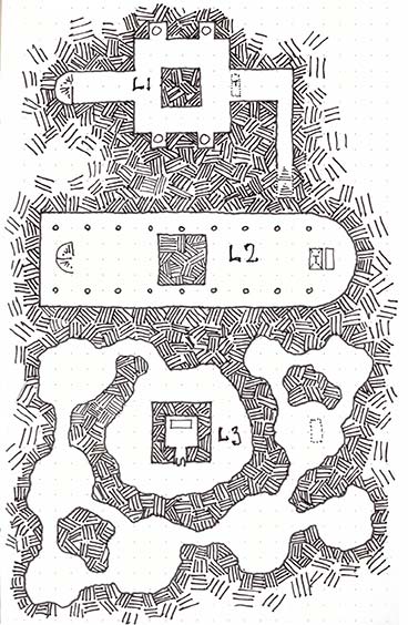
My sons D&D game is now in a Fey palace for a while. A curious thing about this palace is that depending on which door you go out of, it’s a different season outside. This map is the main courtyard inside the palace. There is no roof over the court (the unshaded part of the map) which is sunken about 1 foot below the level of the surrounding walkway. Regularly spaced columns support a balcony above. There are 4 low shrubberies, about 3 feet high. A central sunken pool collects rainwater and the overflow drains into a cistern below. The floor here is polished stone. The floorplan is based on Burghley House, and the court is inspired by the Court of Lions.
This map is 300 dpi. It should fit most VTT systems at 27 columns by 33 rows.
Pencil and pen. Fill in colours done in Photoshop.
Rovers’ End is a small village on the three-way border of Dwarven controlled mountains to the west, human domain to the east, and largely uncontested wilderness to the north. This was a once prosperous village but has fallen on hard times.
I originally used the watabou city generator to make this map, but it’s undergone a few revisions and additions since then. This is the most recent redrawn version.
Rovers’ End
TheTown Square has a well in the middle and hosts a monthly market where farmers from the outlying areas come to sell produce. Dwarven merchants often come into town at market time to sell pots and pans and the like.
TheCouncil Building is where the council meets and is also where town records are kept (although births, deaths, and marriages are recorded at the church). There is almost always at least one council member present here.
The Baker uses locally grown grain ground at the nearby mill and produces good quality bread here. Nothing fancy, but tasty. Villagers buy directly from the baker, but the inn is the bakers’ main customer.
TheLocal Inn is the social heart of the town. Food, drink, lodgings, as well as basic adventuring gear can be purchased here. In more prosperous times, the inn would have often been full, but now many of its rooms sit idle. (I’m using Dyson Logos Wooden Duck Inn map for this.)
The Manor House is where the local lord used to live. The town prospered under his patronage for a while, but strange events cast a shadow over the house, and people started avoiding the town which led to the current decline in the towns fortunes. After the lords’ death, the house has been locked and uninhabited.
The Mill uses a water wheel drive by the river to grind locally grown grain.
The Blacksmith is a gnarly old dwarf with a sour disposition but makes excellent quality metal goods. He typically mends pots and forges plough sheers, but has a small inventory of common weapons for sale to the occasional passing adventurers.
The Docks used to see a lot more use than they do today, with shipments of grain and other goods being sent downriver to the larger towns. Today the docks sit idle a lot of the time except for harvest time, or when the occasional traveller arrives by boat.
The Church is the spiritual heart of the village. Olaf, the head priest, has presided here for many years and is a strict but kind patriarch of the village.
Orchard. Fresh fruits grown here.
The map above is the 72dpi version. The map below is a 300dpi version.
After seeing Dyson Logo’s beautiful little map of Onyx Hill, I decided to have a crack at drawing what lies beneath the hill. I’m planning to add this into my son’s game. I don’t think he’s going to find this site before we get to the location in game.
I figured the base of the onyx pillar would get bigger as it goes down. Perhaps there are some long lost inscriptions on the pillar in the depths. I’ve also added a small hidden nook at the very base.
The trick to getting down to level three is that you actually need to go down the pit trap in front of the altar on level two.
The image above is 72dpi. The image below is300dpi.